Time for some maps
 Today I would like to tell you more about geography and show some maps that will be necessary to understand many things in future. I will start with a map that shows general view of voievodships in Poland. I live in Silesian voivodeship -it is written ŚLĄSKIE on the map . I hope it is easy for you to find it in the southern part of Poland.I have made a special grey spot to make it even more visible.
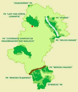
So look on your right now and see the light green colour that shows area of whole Silesian voivodeship- a scale of the map on you right is bit different than a scale of the one above - but it is easy to compare shapes to be sure both comprise the same area. The dark green spots on the map on the right are areas of 8 Nature Parks within boundaries of Silesian voivodeship. Silesian voivodeship doesn't have any National Park till now but who knows what future can bring.
My place of living is where I put a red spot - on the border of Nature Park "Forests upon Upper Liswarta River". The white line is part of Nature Park "Trail of Eagles's Nests" within the area of Silesian Voivodeship ( it is part of Jura Cracow-Czestochowa I was writing about yesterday where National Park is planned to be set up in future). And, finally, the brown line in the southern part of voivodeship marks the border of three mountaineous Nature Parks within Silesian voivodeship that inlude these big parts of Beskidy mountains that lie within Silesian voivodeship of course.
I will write something more about Beskidy soon. Today I can only write that distance between my home (red spot) and Beskidy mountains is about 3-4 hours by train. I have to also add that it is not because it is such a long distance only because trains in Silesian voivodeship go very slow. There are plenty of reasons why some trains can go with a "fascinating" speed of 60 kilometres in...2 hours. Probably the most important is they should be simply modernized. Of course you can take a car but it is not the best solution when you like climbing because you have to go back to the park place what seems to be very uncomfortable solution for mountain hikers.
Soon I will tell you more both about Beskidy mountains and about Nature Park "Forests upon Upper Liswarta" that is adjacent to my home town.
Hope you enjoy reading:)

Komentarze (0):
Prześlij komentarz
Subskrybuj Komentarze do posta [Atom]
<< Strona główna